If you’re planning to drive around Metro Manila this November, particularly in Pasay City, you might want to check your route before leaving home.
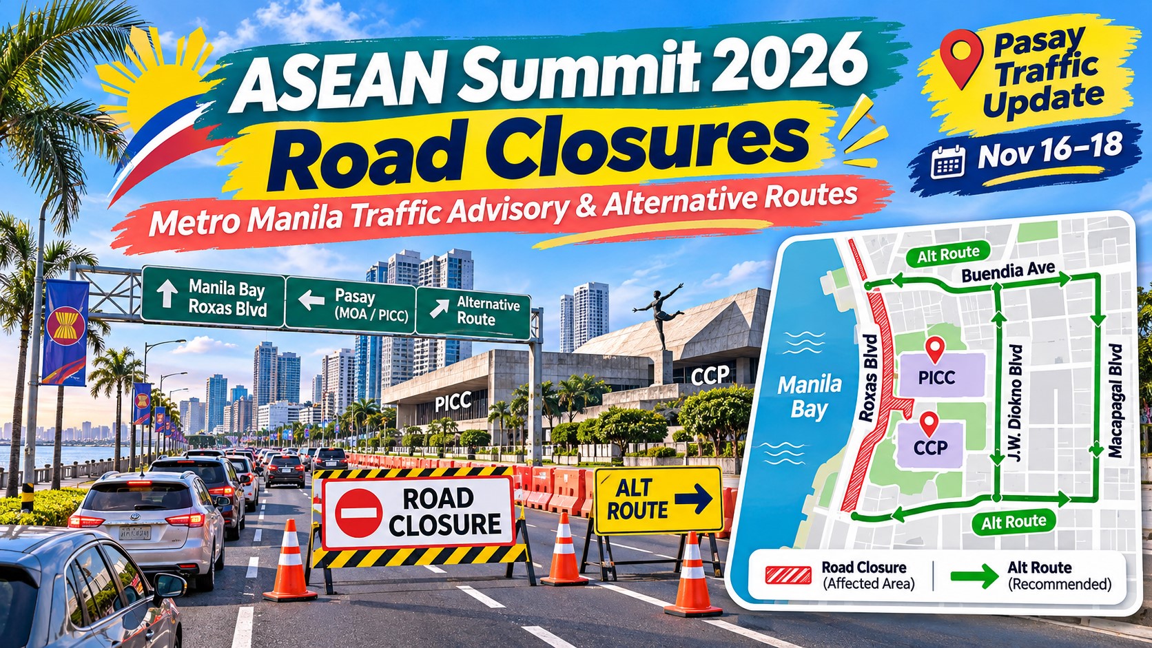
Several roads near the Philippine International Convention Center (PICC) and the Cultural Center of the Philippines (CCP) are subject to temporary closures and traffic restrictions as the Philippines prepares to host the 49th ASEAN Summit and Related Summits on November 16 to 18, 2026.
And these traffic restrictions aren’t limited to the actual summit dates.
According to the Pasay City government, partial road closures began on October 24, while more extensive closures will be implemented beginning November 9 and are scheduled to continue until November 20.
This means motorists, commuters, employees, and travelers heading to certain parts of Pasay could experience traffic disruptions even before the ASEAN Summit officially begins.
Authorities have also identified several major roads where heavy traffic is expected, including Macapagal Boulevard, J.W. Diokno Boulevard, and portions of Roxas Boulevard.
If you regularly pass through the CCP Complex, World Trade Center area, or nearby roads, these are particularly important changes to know about.
To help you plan your trips, here’s a comprehensive guide to the ASEAN Summit 2026 road closures in Metro Manila, including affected streets, traffic rerouting, alternative routes, important dates, and travel reminders.
Content
ASEAN Summit 2026 Road Closures: Latest Traffic Advisory
Here are the most important details from the advisories released by the Pasay City government and traffic authorities.
| Details | Traffic Advisory |
|---|---|
| Event | 49th ASEAN Summit and Related Summits |
| Main summit dates | November 16–18, 2026 |
| Main venue | Philippine International Convention Center, Pasay City |
| Other affected venue | Cultural Center of the Philippines Complex |
| Partial road closures | October 24–November 9 |
| Full road closures | November 9–20 |
| Special non-working days in NCR | November 16–18 |
| Main affected area | PICC, CCP Complex, and surrounding Pasay roads |
| Alternative routes | Via Seaside Boulevard and EDSA, subject to traffic controls |
The road-closure schedule follows the announcement of the Pasay Traffic and Parking Management Office (PTMPO).
One important clarification: the announced closures apply to specific roads and access points around the summit venues. They do not mean that all roads in Pasay or Metro Manila will be closed.
The MMDA has also announced separate security restrictions around the PICC and CCP Complex. Its earlier October 21 advisory referred to a full venue lockdown beginning November 7, while the Pasay road-closure schedule identifies November 9 as the beginning of total road closures.
Because these security and road-access arrangements may be adjusted, motorists should follow the latest instructions from authorities.
Complete List of Roads Affected by the ASEAN Summit 2026
The Pasay Traffic and Parking Management Office has identified several roads surrounding the PICC and CCP Complex that will be affected by temporary traffic restrictions.
These include portions of the following streets:
1. Pedro Bukaneg Street
Pedro Bukaneg Street is one of the roads surrounding the PICC and CCP area.
Security checkpoints and access restrictions may affect vehicles attempting to enter the vicinity.
Motorists with destinations inside the restricted area should verify whether entry is permitted before traveling.
2. Vicente Sotto Street
Vicente Sotto Street is another major road affected by the summit preparations.
The traffic management plan includes the closure of this street within the designated restricted area.
If you normally use Vicente Sotto Street to reach establishments around the CCP Complex, you’ll need to look for another route or confirm whether authorized access is available.
3. J.W. Diokno Boulevard
J.W. Diokno Boulevard is among the roads identified in the Pasay traffic advisory.
This is an important route for motorists traveling around the Bay Area, including those passing near the World Trade Center and connecting roads.
Some sections are affected by summit-related restrictions, while nearby sections may experience additional congestion.
4. Atang Dela Rama Street
Atang Dela Rama Street is another affected road within the CCP and PICC vicinity.
Motorists should expect restricted access and follow instructions from traffic enforcers stationed near the area.
5. Magdalena Jalandoni Street
Magdalena Jalandoni Street has also been identified in published traffic advisories.
Security checkpoints and restrictions are expected around nearby intersections, including the area connecting with Buendia Avenue.
6. Buendia Avenue (Sen. Gil Puyat Avenue)
Portions of Buendia Avenue near the summit venues are included in the affected traffic area.
However, this doesn’t mean the entire length of Buendia Avenue will be closed.
Motorists should distinguish between the restricted sections near the PICC-CCP Complex and the other portions of this major road.
Important: The extent of each closure depends on the security perimeter and traffic management arrangements. Authorities may restrict access to specific segments or intersections rather than closing an entire road from end to end.
Major Roads Motorists Are Advised to Avoid
Aside from streets with announced closures, the Pasay City government has advised motorists to avoid several surrounding roads because of expected heavy traffic.
These include:
- Macapagal Boulevard
- J.W. Diokno Boulevard
- The World Trade Center area
- Affected portions of Roxas Boulevard
These roads serve as important connections between Pasay, Manila, the Mall of Asia area, and other parts of southern Metro Manila.
Because traffic will be diverted away from restricted areas, congestion may build up on nearby roads that remain open.
Keep in mind that a road being included in the avoid list doesn’t necessarily mean it’s completely closed.
Some roads may still be passable but could experience significant delays.
This distinction is important, especially for drivers relying on navigation apps.
ASEAN Summit 2026 Road Closure Schedule
One thing motorists should remember is that the restrictions are being implemented in stages.
Here’s how the announced schedule works.
October 24 to November 8: Partial Road Closures and Security Checks
Limited road access and security measures began on October 24.
During this period, motorists may encounter checkpoints and restricted entry around designated sections of the PICC and CCP Complex.
Some roads may remain accessible, although vehicles entering controlled areas could be subject to screening.
Pasay’s published partial-closure period extends to November 9, which is also the announced transition date to full road closures.
November 9 to 20: Full Road Closures Around Restricted Areas
More extensive restrictions are scheduled beginning November 9.
During this period, certain roads surrounding the summit venues will be inaccessible to ordinary motorists.
Entry into designated security zones may be limited to authorized personnel and vehicles with appropriate credentials.
The city’s advisory identifies November 20 as the scheduled end of the total road-closure period.
November 16 to 18: Main ASEAN Summit Dates
The main summit will take place from November 16 to 18.
These are particularly important dates because international leaders, government delegations, security personnel, and other participants will be attending the meetings.
Motorists should prepare for additional traffic management measures, including possible temporary restrictions along routes used by official convoys.
The exact locations and timing of such restrictions may change depending on operational requirements.
November 19 to 20: Remaining Traffic Restrictions
Although the main summit concludes on November 18, Pasay’s announced road-closure schedule extends to November 20.
Motorists should therefore avoid assuming that every restricted road will reopen immediately after the meetings.
Wait for official confirmation that normal traffic arrangements have resumed.
ASEAN Summit 2026 Alternative Routes and Traffic Rerouting
Now, let’s talk about one of the most important concerns for motorists.
What alternative routes can you take if you’re traveling through the affected areas?
Based on published traffic rerouting advisories, motorists approaching the PICC and World Trade Center areas may be redirected through Seaside Boulevard, Macapagal Boulevard, and EDSA.
For Northbound Motorists Heading Toward Roxas Boulevard
Motorists traveling northbound along J.W. Diokno Boulevard or Macapagal Boulevard toward Roxas Boulevard may be redirected through the following route:
- Proceed toward Seaside Boulevard, where permitted.
- Follow the designated diversion toward Macapagal Boulevard.
- Continue toward EDSA.
- Use the permitted connection from EDSA to Roxas Boulevard.
- Continue toward your destination.
This route is intended to help motorists avoid roads within the restricted summit area.
However, not all sections of Macapagal Boulevard will necessarily be equally accessible.
Drivers should follow directional signs and instructions from traffic enforcers.
For Southbound Motorists Along Roxas Boulevard
Motorists traveling southbound on Roxas Boulevard toward J.W. Diokno Boulevard or Macapagal Boulevard may be redirected through EDSA.
The general diversion is:
- Travel southbound along Roxas Boulevard where permitted.
- Turn toward EDSA at the designated access point.
- Proceed toward the permitted sections of Diokno or Macapagal Boulevard.
- Continue to your destination using roads open to ordinary traffic.
Again, these are the published general rerouting directions, not a guarantee that every connecting segment will remain open throughout the summit preparations.
Temporary changes may be implemented depending on traffic and security conditions.
Quick Alternative Routes Summary
| Travel Direction | Published Alternative |
|---|---|
| Northbound from Diokno/Macapagal toward Roxas Boulevard | Via Seaside Boulevard, Macapagal Boulevard, EDSA, then Roxas Boulevard |
| Southbound from Roxas Boulevard toward Diokno/Macapagal | Via EDSA and permitted connecting roads |
| Traveling directly to PICC or CCP | Check authorized access requirements before entering |
| Traveling around the World Trade Center | Avoid restricted intersections and follow designated detours |
For drivers who aren’t familiar with these roads, I recommend checking Waze or Google Maps before departure.
But remember that a navigation app may not immediately reflect a newly implemented security checkpoint or temporary closure.
When there’s a conflict between your navigation app and instructions from traffic authorities, follow the personnel managing the road.
Will Roxas Boulevard Be Closed During the ASEAN Summit?
This is probably one of the most common questions among motorists who regularly travel between Manila and Pasay.
Based on the announced traffic advisories, portions of Roxas Boulevard are expected to experience traffic restrictions and congestion related to the summit.
However, the published information does not establish a blanket, continuous closure of the entire boulevard.
The situation may be different depending on the specific section you’re using.
For example, motorists traveling near the PICC and CCP Complex could encounter detours or temporary controls.
Meanwhile, sections farther away from the summit venues may continue operating under different traffic arrangements.
The practical advice is to avoid relying entirely on Roxas Boulevard when traveling through the affected Pasay area.
Have an alternative route available, particularly during the main summit dates.
Will EDSA Be Closed During the ASEAN Summit 2026?
There is no announced blanket closure of the entire EDSA corridor in the road advisories covered here.
In fact, EDSA forms part of the published alternative routes for motorists affected by the closures near the PICC and CCP Complex.
That doesn’t mean traffic will necessarily be light.
Some sections of EDSA could experience congestion as vehicles are redirected from nearby roads.
There may also be temporary traffic arrangements associated with official convoy movements.
If EDSA is part of your regular commute, it’s still a good idea to monitor the latest traffic announcements.
Will Macapagal Boulevard Be Closed?
Macapagal Boulevard is one of the major roads motorists have been advised to avoid because of expected heavy traffic.
But being identified as an area to avoid is different from being declared completely closed.
The published rerouting plan also uses certain sections of Macapagal Boulevard as connections for diverted vehicles.
This means accessibility may vary depending on the segment and direction of travel.
If your destination is around Mall of Asia, the World Trade Center, or the Bay Area, make sure to check which intersections remain open.
What About the Mall of Asia Area?
If you’re planning to visit SM Mall of Asia or nearby establishments, traffic conditions may be affected by the restrictions around the broader Pasay Bay Area.
The Mall of Asia complex is not the same as the main summit venue, but nearby roads are connected to the affected traffic network.
Motorists traveling through Diokno Boulevard, Macapagal Boulevard, and connecting streets may encounter congestion.
This doesn’t automatically mean that SM Mall of Asia will be closed or inaccessible.
For shoppers and visitors, the best approach is to check the mall’s own advisories, available entrances, parking access, and the latest traffic situation before traveling.
ASEAN Summit 2026: Travel Advisory for PITX Passengers
For passengers using the Parañaque Integrated Terminal Exchange (PITX), the summit-related restrictions are also worth monitoring.
PITX serves commuters traveling between Metro Manila and several destinations in Cavite, Batangas, and other parts of Luzon.
Although the announced restrictions are concentrated around the PICC and CCP area, traffic congestion on connecting roads could affect travel times for buses, taxis, and private vehicles.
If you’re traveling through PITX during the summit period, keep these reminders in mind:
- Check with your bus operator for any announced route or schedule adjustments.
- Allow additional travel time if your journey includes Pasay’s affected road network.
- Confirm your terminal assignment and departure time before leaving home.
- Avoid assuming that a usual travel duration will apply during the summit.
- Monitor official PITX announcements for operational updates.
As of this article’s November 2 update, the road-closure advisories reviewed do not announce a complete shutdown of PITX.
Will the EDSA Busway and Other Public Transportation Be Affected?
Another important part of the summit traffic management plan involves designated bus lanes.
According to the Pasay City government’s advisory, designated bus lanes will temporarily serve as ASEAN lanes to prioritize official vehicles and delegations.
This is intended to facilitate the movement of summit participants.
However, this announcement should not automatically be interpreted as a complete suspension of the EDSA Busway or all bus services.
Commuters should wait for specific announcements from the Department of Transportation, MMDA, and transport operators regarding any stop changes, temporary restrictions, or service adjustments.
For passengers using LRT-1, MRT-3, or other public transportation systems, check official operating schedules rather than assuming that railway services will be suspended.
A public holiday or road closure does not automatically mean that trains will stop operating.
Traveling to NAIA During the ASEAN Summit? Here’s What to Know
If you have a flight departing from Ninoy Aquino International Airport during the ASEAN Summit period, I would recommend paying extra attention to your travel plans.
The summit will bring international delegations and government officials to Metro Manila.
Aside from traffic restrictions on certain roads, airline operations may also be affected by airport arrangements associated with the event.
Some airlines have already announced adjustments to selected flights during the summit period.
For passengers traveling to NAIA, here are a few practical reminders.
Check Your Flight Status
Before leaving for the airport, check your airline’s official website or mobile application.
Don’t rely entirely on your original booking confirmation because schedules may change.
Allow More Time for Airport Transfers
If you’re traveling from Cavite, Laguna, Batangas, Manila, or other parts of Metro Manila, account for possible congestion on roads leading toward Pasay and airport access points.
The amount of extra time you’ll need will depend on your origin, flight schedule, and traffic conditions.
Check the Best Available Route
Depending on your location, expressways and major roads may offer different airport access options.
However, you should not assume a specific road will remain unaffected by temporary traffic controls.
Use current traffic information before selecting a route.
Monitor Airline Advisories
If your flight has been canceled or rescheduled, contact the airline directly to review your available rebooking, refund, or other options.
For confirmed flight changes, always rely on the airline’s latest advisory rather than an outdated social media post.
November 16–18, 2026 Declared Special Non-Working Days in Metro Manila
Another major announcement related to the ASEAN Summit is the declaration of special non-working days in Metro Manila.
Under Proclamation No. 1447, Malacañang has declared the following dates as special non-working days throughout the National Capital Region:
| Date | Day | Classification |
|---|---|---|
| November 16, 2026 | Monday | Special non-working day |
| November 17, 2026 | Tuesday | Special non-working day |
| November 18, 2026 | Wednesday | Special non-working day |
The declaration is intended to help ease congestion and support safety and security arrangements during the summit.
It’s important to remember that the proclamation covers the National Capital Region.
It does not automatically extend to provinces outside Metro Manila, including Cavite, Laguna, Bulacan, and Rizal.
Employees should check with their respective employers regarding work arrangements and the applicable holiday pay rules.
Government offices, private establishments, transport services, and other operations may also issue separate schedules.
ASEAN Summit 2026: Restrictions on Fun Runs, Motorcades and Other Public Events
The traffic arrangements aren’t limited to road closures.
The Metropolitan Manila Development Authority has also announced a temporary suspension of the issuance of permits for certain public activities.
The restrictions cover fun runs, motorcades, processions, and similar public events from October 24 to November 20, 2026.
The cities covered by the measure include:
- Manila
- Pasay
- Parañaque
- Makati
- Taguig
The purpose is to support summit preparations and reduce potential disruptions to traffic and security operations.
This does not mean that every event across these cities has automatically been canceled.
Organizers and participants should verify the status of their particular activity with the relevant local government unit or event organizer.
MMDA Suspends Road Excavation Works in Metro Manila
Another measure announced by the MMDA is a moratorium on road excavation works.
The suspension began on November 1 and is scheduled to remain in effect until midnight of December 23, 2026.
This measure is intended to reduce additional road disruptions during the summit preparations and the busy Christmas travel season.
The restriction is particularly relevant because roadworks can create bottlenecks even during ordinary traffic conditions.
By minimizing excavation activities, authorities aim to help maintain smoother movement along Metro Manila’s major roads.
Of course, the suspension of roadworks doesn’t eliminate existing traffic congestion or restrictions associated with the summit.
Motorists should still expect possible delays along affected routes.
Can Employees Enter Restricted Areas Around PICC and CCP?
What if your office is located near the PICC or CCP Complex?
According to the Pasay City advisory, employees working within affected areas may be allowed to enter or pass through upon presentation of a valid company identification card.
However, access remains subject to security protocols.
This means simply showing an ID may not guarantee immediate entry if additional screening or restrictions are in effect.
If your workplace is inside or near a designated security zone, I recommend checking directly with your employer before reporting for work.
Your company may provide additional instructions regarding entry points, identification requirements, or alternative working arrangements.
How to Avoid Heavy Traffic During the ASEAN Summit 2026
If you absolutely need to travel through Metro Manila during the summit period, a little preparation can make a big difference.
Here are some practical suggestions.
1. Avoid the PICC and CCP Area Unless Necessary
This is the most straightforward advice.
If your destination isn’t actually inside the restricted area, avoid taking roads immediately surrounding the summit venues.
2. Check Traffic Conditions Before Leaving
Use navigation apps and official traffic updates to identify congestion and closures.
But remember that security-related restrictions can change quickly.
3. Consider Alternative Transportation
Depending on your origin and destination, rail services may help reduce your dependence on congested roads.
Just make sure to check for any service changes beforehand.
4. Allow Extra Time for Important Appointments
This is particularly important if you’re heading to the airport, attending a medical appointment, or reporting for work.
Don’t assume that your regular travel time will be enough.
5. Follow Traffic Enforcers
Even if your navigation app recommends a particular road, follow authorized traffic personnel when a temporary closure is in place.
6. Avoid Spreading Unverified Road Closure Announcements
Not every social media post about the ASEAN Summit will necessarily be accurate.
For example, an advisory from the 2017 ASEAN Summit may have a different road-closure plan from the one being implemented in 2026.
Always check the date and source of an announcement before sharing it.
Where to Check Official ASEAN Summit Traffic Updates
Because road closures and security arrangements may change as the summit approaches, it’s important to monitor announcements directly from government agencies.
Here are some useful sources:
Metropolitan Manila Development Authority (MMDA)
Website: https://mmda.gov.ph/
Check for traffic management announcements, road restrictions, and rerouting advisories.
Pasay City Government
Official website: https://www.pasay.gov.ph/
Watch for announcements from the Pasay City Public Information Office and the Pasay Traffic and Parking Management Office.
Philippine Information Agency
Official website: https://pia.gov.ph/
Provides government announcements and public advisories related to the summit.
Department of Transportation
Official website: https://dotr.gov.ph/
Check for transportation-related updates, particularly if you’re using public transportation.
Presidential Communications Office
Official website: https://pco.gov.ph/
Provides official government announcements, including declarations related to the summit.
For the current reported closure schedule, you can also refer to the Philippine Information Agency’s October 27 Pasay road-closure advisory.
Frequently Asked Questions About ASEAN Summit 2026 Road Closures
When will the ASEAN Summit 2026 road closures start?
Partial restrictions began on October 24, 2026.
Pasay City has announced full road closures beginning November 9 and continuing until November 20 in designated areas near the PICC and CCP Complex.
When is the ASEAN Summit 2026 in the Philippines?
The main 49th ASEAN Summit and Related Summits will take place in Metro Manila from November 16 to 18, 2026.
Which roads will be closed for the ASEAN Summit?
Affected streets around the PICC and CCP Complex include portions of Pedro Bukaneg Street, Vicente Sotto Street, J.W. Diokno Boulevard, Atang Dela Rama Street, Magdalena Jalandoni Street, and Buendia Avenue.
Is Roxas Boulevard closed during the ASEAN Summit?
Portions of Roxas Boulevard may be affected by traffic controls and congestion.
However, the published announcements do not establish that the entire length of Roxas Boulevard will be closed throughout the summit period.
Is EDSA closed during the ASEAN Summit 2026?
There is no blanket closure of the entire EDSA corridor in the advisories reviewed as of November 2.
EDSA is also part of the announced alternative routes for some motorists affected by the Pasay road closures.
Will Macapagal Boulevard be closed?
Macapagal Boulevard is among the roads motorists are advised to avoid because of expected heavy traffic.
Accessibility may vary by section, particularly near the roads connecting to the restricted summit area.
What are the alternative routes during the ASEAN Summit?
Motorists heading northbound toward Roxas Boulevard from Diokno or Macapagal Boulevards may be diverted through Seaside Boulevard and EDSA.
Southbound motorists may also be redirected through EDSA.
Follow the latest posted route instructions, since access may change during security operations.
Is November 16, 2026 a holiday in Metro Manila?
Yes. November 16, 17, and 18, 2026 have been declared special non-working days in the National Capital Region under Proclamation No. 1447.
Will the road closures affect NAIA passengers?
Travelers heading to NAIA may encounter additional traffic congestion or temporary traffic controls.
Air passengers should also check their flight schedules because some airlines have announced summit-related adjustments.
Will PITX be closed during the ASEAN Summit?
The advisories reviewed as of November 2 do not announce a complete PITX closure.
However, passengers should monitor possible transportation and traffic adjustments.
Can employees enter the PICC and CCP restricted areas?
Employees working in affected locations may be allowed to enter upon presentation of valid company identification, subject to security screening and access rules.
When will the roads reopen?
The Pasay City road-closure advisory schedules the end of full road closures for November 20, 2026.
Actual reopening arrangements remain subject to official instructions.
Final Thoughts
With the Philippines hosting the 49th ASEAN Summit this November, motorists and commuters in Metro Manila should prepare for temporary road closures, traffic rerouting, and additional security measures.
The main areas to watch are the roads surrounding the Philippine International Convention Center and Cultural Center of the Philippines in Pasay City.
Partial closures started on October 24, while full road closures are scheduled from November 9 to 20.
Authorities have also advised motorists to avoid Macapagal Boulevard, the World Trade Center area, J.W. Diokno Boulevard, and affected sections of Roxas Boulevard because of expected traffic congestion.
If you’re traveling to Pasay, heading to NAIA, using PITX, or passing through nearby roads, my advice is simple: plan your trip early and check the latest traffic advisories before leaving.
And remember, the road closures may continue even after the main summit concludes on November 18.
A little preparation can save you from unnecessary delays, especially if you have important appointments or travel plans.
This article will need updating if the MMDA, Pasay City government, or other authorities announce additional road closures, revised schedules, or new traffic rerouting arrangements.
References
- Philippine Information Agency – Pasay LGU Implements Temporary Road Closures for ASEAN Summit
- Philippine Information Agency – Government Traffic Preparations for the 49th ASEAN Summit
- Presidential Communications Office – November 16–18 Special Non-Working Days
- GMA News – Pasay City Road Closures for ASEAN Summit 2026
- Philstar – ASEAN Summit Road Closures and Flight Changes
- SPOT.ph – ASEAN Summit 2026 Traffic Rerouting Guide