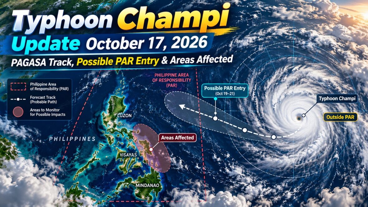
Typhoon Champi is gaining strength over the western Pacific Ocean, and weather authorities are closely monitoring its movement as it approaches the Philippine Area of Responsibility (PAR).
As of Saturday, October 17, 2026, Champi remains outside PAR, but its west-northwestward movement has raised the possibility that it could enter the country’s monitoring area early next week.
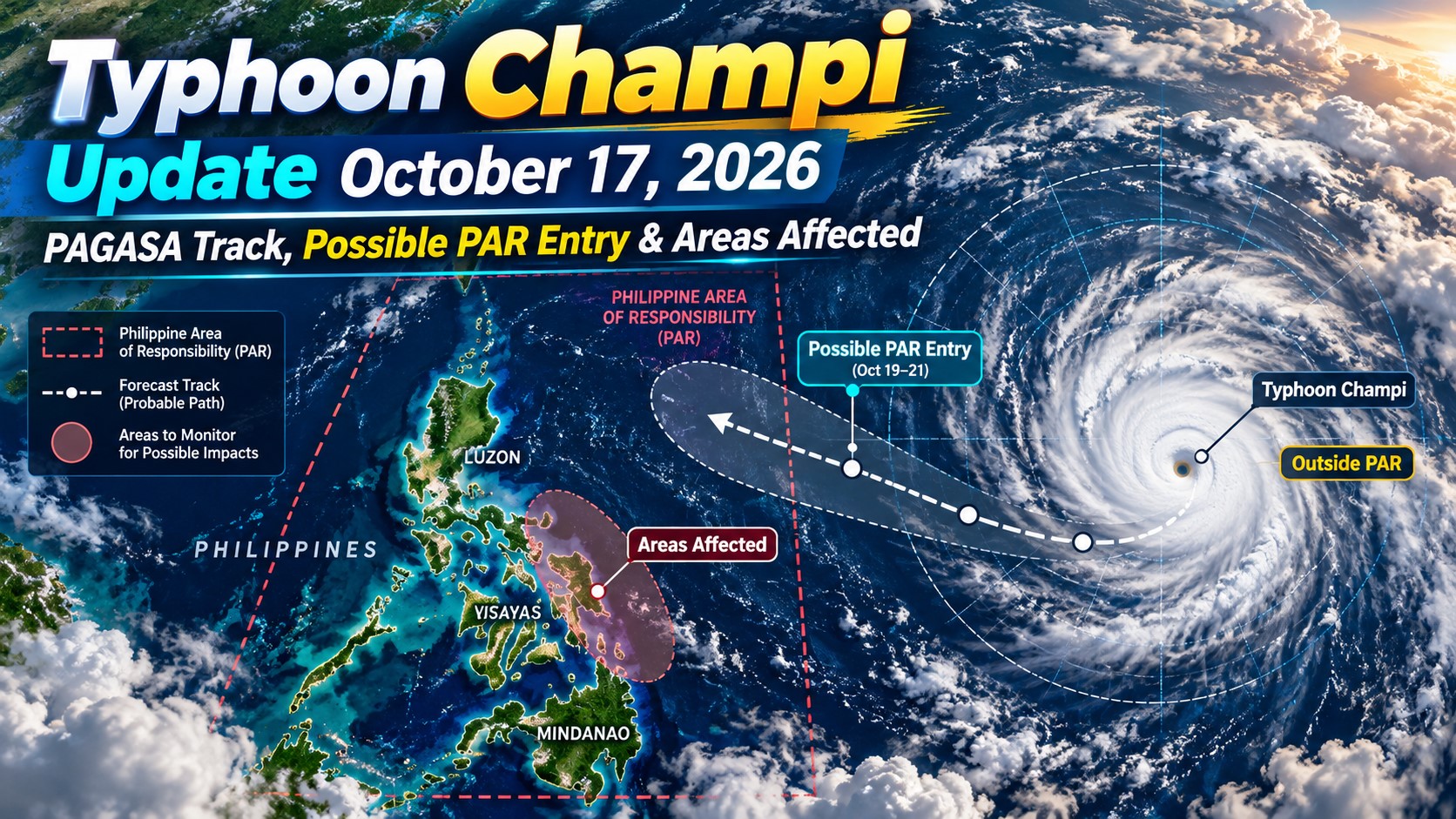
According to PAGASA, the typhoon is expected to approach PAR around Tuesday, October 20, or Wednesday, October 21. It could intensify further over the warm waters of the Pacific, potentially reaching super typhoon strength.
However, there is some reassuring news. Current forecasts indicate a low likelihood of Champi making landfall in the Philippines, although its outer rainbands or trough could still influence weather conditions in parts of the country.
So, where exactly is Typhoon Champi now? When could it enter PAR? And which areas in the Philippines should prepare for possible rainfall?
Here’s what we know based on the latest available PAGASA information.
Content
Typhoon Champi Latest Update: October 17, 2026
PAGASA continues to monitor Typhoon Champi as it moves across the Pacific Ocean east of the Philippines.
Based on the reported 8:00 AM observation on Saturday, October 17, Champi was located approximately 2,520 kilometers east of Eastern Visayas.
The typhoon had maximum sustained winds of 140 kilometers per hour near its center, with gusts reaching 170 kilometers per hour.
It was moving west-northwestward at approximately 30 kilometers per hour.
Latest Typhoon Champi Information
| Details | Latest reported information |
|---|---|
| International Name | Champi |
| Classification | Typhoon |
| Date | October 17, 2026 |
| Observation Time | 8:00 AM |
| Location | 2,520 km east of Eastern Visayas |
| Coordinates | 12.3°N, 148.6°E |
| Maximum Sustained Winds | 140 km/h |
| Gustiness | Up to 170 km/h |
| Movement | West-northwestward |
| Speed | 30 km/h |
| PAR Status | Outside PAR |
| Possible PAR Entry | October 20–21, subject to changes |
| Possible Philippine Name | Rosal |
Earlier, PAGASA’s 3:00 AM weather information placed Champi approximately 2,675 kilometers east of Eastern Visayas, moving west-northwestward at 25 kilometers per hour.
These observations show the typhoon continuing its movement toward the general direction of the Philippine Sea.
Still, Champi remains far from the Philippine mainland. Its current strength should not be confused with the wind conditions being experienced across the country.
When Will Typhoon Champi Enter PAR?
One of the biggest questions right now is whether Typhoon Champi will enter the Philippine Area of Responsibility.
Based on PAGASA forecasts discussed on October 16 and reported on October 17, Champi could cross into PAR around Tuesday, October 20, or Wednesday, October 21.
PAGASA’s weekly weather outlook, covering October 16 to 23, also anticipates a tropical cyclone entering PAR during the October 19–22 period.
Of course, the exact timing will depend on how the typhoon moves over the next several days.
A faster westward movement could bring Champi closer to the PAR boundary earlier than expected. On the other hand, changes in the storm’s direction could affect both its arrival time and how much of its circulation enters the monitoring area.
It’s also important to understand that entering PAR doesn’t automatically mean a typhoon will hit the Philippines.
PAR is a large monitoring area covering parts of the western Pacific Ocean and surrounding waters. Tropical cyclones can enter this area without making landfall or directly affecting populated communities.
For Champi, its eventual track across the Philippine Sea will determine whether the country experiences significant rainfall, strong winds, or only limited indirect effects.
Typhoon Champi PAGASA Track: Where Is It Heading?
As of October 17, Champi is moving west-northwestward over the western Pacific.
Forecast discussions indicate that the typhoon could continue toward the Philippine Sea before eventually turning more northwestward or northward.
One possible scenario takes Champi over waters east or northeast of the Philippines, potentially toward the general vicinity of Taiwan or the Ryukyu Islands of southern Japan later next week.
This is an outlook rather than a confirmed future track.
PAGASA and other meteorological agencies will continue analyzing atmospheric conditions that can influence Champi’s movement.
These include surrounding high-pressure systems, steering winds, and changes in the broader atmospheric circulation.
Even small changes in a typhoon’s track several days in advance can make a significant difference in its eventual impact.
For now, the important takeaway is that Champi is approaching the general direction of PAR, but a direct crossing of the Philippine mainland is not the expected scenario based on the forecast information available on October 17.
Will Typhoon Champi Make Landfall in the Philippines?
Based on PAGASA’s forecast discussion reported on October 17, the possibility of Typhoon Champi making landfall in the Philippines is considered low.
Current indications favor a track over the Philippine Sea, potentially keeping the typhoon’s center away from the country’s landmass.
However, that doesn’t mean everyone can completely ignore the storm.
A typhoon doesn’t necessarily have to make landfall to affect the weather.
Its extensive cloud formations, rainbands, and associated trough can bring rainfall to places located far from the center.
Coastal waters may also become rough when a powerful tropical cyclone approaches, depending on its distance, strength, and the direction of its winds and waves.
For this reason, residents, travelers, and fishermen should continue checking PAGASA’s official updates rather than relying on a single forecast track.
Could Champi Become a Super Typhoon?
Yes. Forecasts have indicated that Typhoon Champi has the potential to intensify significantly as it moves across the Pacific.
The storm is traveling over an ocean environment that may support further strengthening.
Warm sea surface temperatures provide energy for tropical cyclones, while favorable atmospheric conditions can help them develop stronger winds.
Some forecasts have suggested that Champi could eventually reach super typhoon intensity.
However, as of the October 17 morning observations used in this report, PAGASA classified Champi as a typhoon with maximum sustained winds of 140 km/h.
It was not yet classified as a super typhoon in that observation.
In the Philippines, PAGASA classifies tropical cyclones as super typhoons when their maximum sustained winds reach at least 185 km/h.
Whether Champi reaches that level will depend on how atmospheric and ocean conditions develop.
Areas in the Philippines That May Be Affected by Typhoon Champi
Although Typhoon Champi remains outside PAR, PAGASA’s extended forecast already identifies several regions that could experience rainfall associated with the trough of a tropical cyclone early next week.
Visayas
The Visayas is among the areas to monitor as Champi approaches PAR.
According to PAGASA’s weekly outlook, cloudy skies with scattered rains and thunderstorms are expected over parts of the Visayas from Monday, October 19, through Thursday, October 22, due to the trough of a tropical cyclone.
Eastern-facing provinces, including parts of Samar and Leyte, should pay attention to any changes in Champi’s movement.
However, this does not mean that every province in the Visayas will experience severe weather or typhoon-force winds.
The location and intensity of rainfall will depend on the actual development and position of the storm.
Caraga Region
Caraga in northeastern Mindanao is another area highlighted in PAGASA’s extended weather outlook.
The region may experience cloudy skies accompanied by scattered rains and thunderstorms as the tropical cyclone’s trough influences the weather.
Residents in flood-prone and landslide-prone communities should monitor rainfall advisories, especially if thunderstorms become persistent or intense.
Northern Mindanao
PAGASA also expects the trough of the approaching tropical cyclone to bring scattered rains and thunderstorms to Northern Mindanao during the October 19–22 forecast period.
Although the typhoon’s center is not expected to directly cross the region based on the current outlook, rainfall can still affect outdoor activities, road travel, and vulnerable communities.
Eastern Luzon and Bicol Region
Parts of eastern Luzon and the Bicol Region may also need to monitor the developing weather situation.
Depending on Champi’s eventual track, its broader circulation could affect portions of the country’s eastern seaboard.
However, the October 17 PAGASA forecast attributes the scattered rainfall currently expected over Bicol, Aurora, and Quezon primarily to the easterlies, rather than directly to Champi.
Residents should therefore distinguish between rainfall caused by existing weather systems and any additional effects that might develop as the typhoon approaches.
Metro Manila and Nearby Provinces
For Metro Manila, Cavite, Laguna, Batangas, Rizal, Bulacan, and surrounding areas, the October 17 forecast does not identify Champi as a direct source of severe weather.
PAGASA expects generally partly cloudy to cloudy skies with isolated rainshowers or thunderstorms across Metro Manila and much of Luzon.
These conditions are primarily associated with the easterlies and localized thunderstorms.
Nevertheless, forecast conditions could change depending on the typhoon’s eventual position and size.
PAGASA Weather Forecast Today, October 17
While attention is focused on Typhoon Champi, several other weather systems are already affecting the Philippines.
According to PAGASA’s 4:00 AM weather forecast on Saturday, October 17, the Intertropical Convergence Zone (ITCZ) is influencing Palawan, the Visayas, and Mindanao.
The easterlies are affecting much of Luzon, while northeasterly windflow is influencing Extreme Northern Luzon.
Here’s what to expect across the country.
Mindanao, Western Visayas, Negros Island Region, Cebu, and Palawan
These areas may experience cloudy skies with scattered rains and thunderstorms due to the ITCZ.
Moderate to occasionally heavy rainfall could cause flash floods or landslides in vulnerable locations.
Bicol Region, Quezon, Aurora, and the Rest of MIMAROPA
Cloudy skies with scattered rains and thunderstorms are expected due to the easterlies.
Residents in flood-prone communities should be careful during prolonged or heavy rainfall.
Batanes and Babuyan Islands
Partly cloudy to cloudy skies with isolated light rains are expected due to northeasterly windflow.
Metro Manila and the Rest of Luzon
Generally partly cloudy to cloudy skies with isolated rainshowers or thunderstorms are expected.
Severe localized thunderstorms may still produce heavy downpours and temporary flooding.
Rest of the Visayas
Other areas of the Visayas may experience partly cloudy to cloudy skies with isolated rainshowers or thunderstorms associated with the ITCZ.
These forecasts refer to prevailing weather conditions on October 17 and should not automatically be interpreted as direct effects of Typhoon Champi.
Weather Outlook for October 18–23, 2026
PAGASA’s weekly outlook provides an early picture of how the weather may develop while Champi approaches PAR.
Sunday, October 18
The easterlies are expected to bring cloudy skies with scattered rains and thunderstorms over the Visayas, Bicol Region, MIMAROPA, and Quezon.
Other parts of the country may experience isolated rainshowers or thunderstorms, particularly during the afternoon and evening.
Monday to Thursday, October 19–22
PAGASA expects the trough of a tropical cyclone approaching or entering PAR to influence the weather over the Visayas, Caraga, and Northern Mindanao.
These areas may experience cloudy skies with scattered rains and thunderstorms.
Other regions are generally forecast to have partly cloudy to cloudy skies, with isolated rainshowers or thunderstorms.
Friday, October 23
The country may generally experience partly cloudy to cloudy skies with isolated rainshowers or thunderstorms, especially during the afternoon and evening.
Keep in mind that these are extended forecasts. PAGASA may revise them if Champi’s track, strength, or associated weather systems change.
Will Typhoon Champi Be Named Rosal?
If Typhoon Champi enters the Philippine Area of Responsibility and Rosal remains the next unused name on PAGASA’s 2026 list, it will be assigned the local name Rosal.
This is consistent with PAGASA’s naming system, which assigns Philippine names to tropical cyclones entering or developing within PAR.
The storm would continue to be called Champi internationally.
This means that Typhoon Champi and Typhoon Rosal would refer to the same tropical cyclone, rather than two separate storms.
The local name would be officially used once PAGASA confirms the storm’s entry into PAR and assigns the designation.
Is There a Tropical Cyclone Wind Signal in the Philippines?
As of the October 17 morning information reviewed for this report, Typhoon Champi remains outside PAR, and PAGASA has not indicated any Tropical Cyclone Wind Signal associated with Champi over Philippine provinces.
That is understandable considering the typhoon’s considerable distance from the country.
However, wind signals are not the only weather warnings people should monitor.
Heavy rainfall advisories, thunderstorm warnings, flood alerts, and marine warnings can also be important, particularly when other weather systems are active.
Residents should follow the specific advisories issued for their localities.
Could Typhoon Champi Affect Flights and Ferry Trips?
Travelers planning domestic flights, international connections, or ferry journeys over the next several days should keep an eye on the forecast.
At this stage, Champi’s reported position does not by itself establish that Philippine flights or ferry services will be disrupted.
However, changes in weather conditions could affect transport operations if the storm moves closer to the country’s eastern waters.
For domestic flights, airports serving destinations in the Visayas and Mindanao may experience thunderstorms from the weather systems identified in PAGASA’s outlook.
For sea travel, rough coastal conditions could become a concern if Champi’s circulation or associated waves affect Philippine waters.
Whether any route will experience disruptions depends on updated weather advisories and decisions made by airlines, shipping operators, and relevant authorities.
Passengers should check their flight or ferry status before leaving for the airport or port.
It’s also advisable to allow extra travel time during periods of heavy rainfall.
What Should Filipinos Do While Monitoring Champi?
Even though direct landfall is currently considered unlikely, it is still wise to prepare for possible changes in the weather.
Here are a few practical precautions:
- Check PAGASA weather updates regularly, especially from October 19 onward.
- Monitor local rainfall advisories if you live in flood-prone areas.
- Avoid unnecessary travel through flooded roads during heavy thunderstorms.
- Prepare emergency essentials, including drinking water, medicines, flashlights, batteries, and power banks.
- Secure outdoor objects that could be blown away if strong winds develop.
- Fishermen and boat operators should follow official marine forecasts and warnings.
- Travelers should check airline, ferry, and local government advisories before their departure.
Remember that the situation can change. A typhoon that initially appears unlikely to make landfall can still require additional precautions if its forecast track shifts.
Frequently Asked Questions About Typhoon Champi
Where is Typhoon Champi now?
As of the reported 8:00 AM observation on October 17, 2026, Typhoon Champi was approximately 2,520 kilometers east of Eastern Visayas, with maximum sustained winds of 140 km/h and gustiness reaching 170 km/h.
Has Typhoon Champi entered PAR?
No. Based on the October 17 morning information, Champi remains outside the Philippine Area of Responsibility.
When is Typhoon Champi expected to enter PAR?
PAGASA forecasts indicate a possible entry around October 20 or 21, although the exact date could change.
What will be the Philippine name of Typhoon Champi?
Champi is expected to receive the local name Rosal if it enters PAR and that remains the next name available on PAGASA’s naming list.
Will Typhoon Champi hit the Philippines?
Current forecast discussions indicate a low likelihood of landfall in the Philippines. However, the typhoon’s trough or outer circulation could still affect the weather over parts of the country.
Which areas may experience rain because of Champi?
PAGASA’s October 16 weekly outlook identifies the Visayas, Caraga, and Northern Mindanao as areas that may experience scattered rains and thunderstorms due to the trough of a tropical cyclone during October 19–22.
Is Typhoon Champi already a super typhoon?
No. Based on the October 17 morning observation, Champi was classified by PAGASA as a typhoon. Further intensification is possible, but super typhoon strength had not yet been reached in that observation.
Are there storm warning signals in Metro Manila?
There were no Tropical Cyclone Wind Signals indicated for Metro Manila due to Champi in the PAGASA information reviewed for this update.
Final Thoughts
Typhoon Champi is certainly worth monitoring over the coming days, especially with forecasts suggesting that it could become significantly stronger while approaching the Philippine Area of Responsibility.
As of October 17, 2026, the typhoon remains far east of the Philippines, with maximum sustained winds of 140 km/h and a general west-northwestward movement.
PAGASA expects a possible PAR entry around October 20 or 21, at which point Champi may receive the local name Rosal.
The encouraging part is that a direct landfall in the Philippines is currently considered unlikely.
Still, the possibility of rainfall associated with the storm’s trough means residents in the Visayas, Caraga, Northern Mindanao, and other potentially affected areas should continue monitoring official forecasts.
For travelers, especially those planning flights, ferry trips, or outdoor activities next week, checking updated weather advisories is a sensible precaution.
We’ll continue following Typhoon Champi’s developments as PAGASA releases updated information on its movement, intensity, and potential effects.
For now, stay informed, prepare for changing weather conditions, and remember that a forecast is not a guarantee of what will happen.
Weather information is based on PAGASA forecasts and reports available on October 17, 2026. Tropical cyclone conditions may change rapidly. Always refer to the latest official PAGASA advisories and local government announcements for safety decisions.